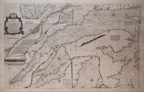
Thomas Jefferys (English, ca. 1719-1771), Exact Chart of the River St. Laurence from Fort Frontenac to the Island of Anticosti...
Thomas Jefferys (English, ca. 1719-1771)
Exact Chart of the River St. Laurence from Fort Frontenac to the Island of Anticosti shewing the Soundings, Rocks, Shoals &c with Views of the Lands and all necessary Instructions for navigating that River to Quebec
From: Jefferys’ American Atlas
Published, Robert Sayer, 1775
Engraving with original outline hand-coloring. This map illustrates the length of the St. Laurence river through a series of inset maps.
Paper size 25 ¾ x 40”
p.m. 23 ¾ x 37 ½”
We Also Recommend
![Abraham Ortelius (Flemish 1527-1598), Peruviae Auriferae Regionis Typus [with] La Florida Auctore Hieron Chiaves [with] Guastecan Reg.](http://aradergalleries.com/cdn/shop/products/Peruviae_Auriferae-Ortelius_large.jpg?v=1475527180)