Thomas Holme (1624–1695), A Mapp of ye Improved Part of Pennsylvania...
Thomas Holme (1624–1695)
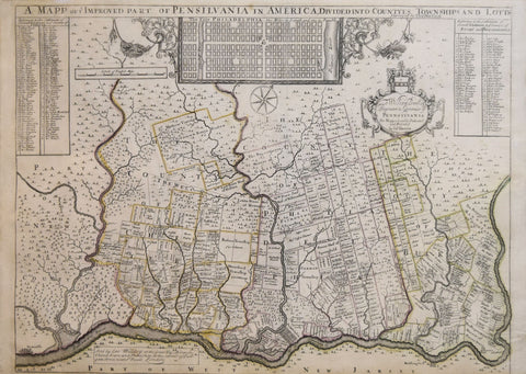
A Mapp of ye Improved Part of Pennsylvania...
Published: London, by Philip Lea ca. 1715
Medium: Engraving by John Harris (fl. 1686-1730)
Sheet size: 16 x 22 1/2 inches
THE FIRST MAP OF PENNSYLVANIA: "without question the finest printed cartographic document relating to North America to be published to date" (Burden).
First single sheet edition, second issue with Lea's imprint erased and a simple rectangular box lower left stating Willdey as the seller of the map, reduced from an original seven-sheet map for printed for the political use of William Penn and his associates, or the "more notable wealthy citizens of the colony" (Burden).
Holmes' map depicts the settled, outlying regions of Philadelphia, and also contains an inset, modestly-sized plan of the aforementioned city. The dominant map depicts William Penn's own manor of Pennsbury upriver to Newcastle, and, further inland, the present-day sites of West Chester and Doylestown. In addition, the map lists the names and depicts the properties of the hundreds of settlers who inhabited the region. Penn, a Quaker and founder of the Pennsylvania colony, commissioned Holme to create this map as a means of advertising the settlement abroad. Penn's incredible knack for salesmanship helped the region become the most swiftly occupied North American colony to date.
Holme, Pennsylvania's first Surveyor General, played a primary role in the planning of the City of Philadelphia, and had also won great acclaim for his outstanding 1683 map of the then infant city entitled, Portraiture of the City of Philadelphia. Thus, by 1688 Penn could have found no more qualified candidate than Holme to create the first map of Pennsylvania's settlements. After Holme completed drafting the map, Penn enlisted Francis Lamb to engrave it. Penn's old friend John Thornton and Robert Greene took charge of the map's publication. The version of the map shown here, is a single sheet reduction of Holme's original seven-sheet work.
Once Lea controlled the rights to the map, he ordered a number of changes be made to the plate before releasing his own edition of it. Such changes largely resulted from Lea's desire to broaden the map's appeal to a group of buyers that went beyond mere politicians and wealthy Pennsylvanian settlers. Thus, he reduced the original seven-sheet version to one sheet. Nevertheless, Lea's edition of the map preserved many of the original features of the earlier map. For example, the plan of Philadelphia is merely shifted to the top and center of the map, and the dedication is kept intact. Moreover, since the shrunken size of many of the new land lots contained in the updated version of the map could no longer hold the names of its owners, Lea listed the names of these owners in a keyed table on the upper right corner of the map. Toponyms are also preserved, but slightly adjusted so as to appear more level on the surface of the map.
Gloria Gilda Deak, Picturing America, 1497-1899 (Princeton, 1988), no. 72; Philip D. Burden, The Mapping of North America II: A List of Printed Maps 1671-1700 (Rickmansworth, 2007), 669
We Also Recommend


