John Speed (1552-1629), A New Map of East India
John Speed (1552-1629)
A New Map of East India
London: Basset and Richard Chiswell, c. 1676
Copperplate engraving
Paper size: 17" x 21 1/2"
Fine Map of Southeast Asia, part of the Expanded Edition of the First World Atlas Prepared by an Englishman
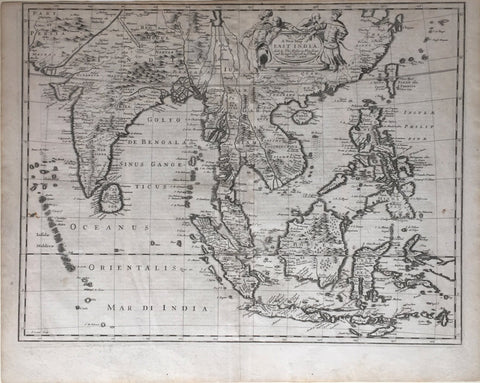
This is a nice example of John Speed's map of Southeast Asia, China, Taiwan and part of India, which was engraved by Francis Lamb and first appeared in the enlarged edition of Speed's world atlas in 1676.
The map covers Southeast Asia, from the Maldives and India to modern Indonesia, Malaysia, and the Philippines. Mountains and forests are marked in the interiors of the continents and larger islands, while important cities are marked with a house symbol.
There is little decoration aside from the islands themselves, although there is an illustrated cartouche inland in China. It declares the map's title and distributors inside a frame. Around the frame are four Asian men, two in elaborate outfits. To the left is a man with mustache, turban, and bow. To the right, another gentleman is in Chinese dress. On the verso, Speed's map includes a fascinatingly Anglo-centric description in English text.
The map shows the long-held European assumption that all rivers in Asia had a common source. Here, it is the Chiamay Lacus, which gives rise to four rivers that flow south into Indochina. Other geographers had the lake doing even more fluvial work; Blaeu had Lake Chiamay, near Tartary, as the start of six rivers. A major catalyst for this particular cartographic configuration was Matteo Ricci, the Jesuit cartographer. He includes Lake Chiamay on his maps, an idea he probably picked up from European maps he carried with him to China, as well by reading Bon Po and Buddhist doctrines.
This is one of a small group of new maps added by Thomas Bassett and Richard Chiswell to the 1676 edition of John Speed's famous atlas, A Prospect of the Most Famous Parts of the World. The maps were engraved by Francis Lamb, as Speed had been dead for half a century by the time these maps were engraved.
Speed's Theatre and Prospect in the history of cartography
John Speed (1552-1629) was an English mapmaker and historian operating in London at the turn of the seventeenth century; he was the most famous Stuart cartographer. In 1611/1612, John Sudbury and George Humble published the first edition of his famous work, The Theatre of the Empire of Great Britain, which covered the British Isles. In 1627, he released the second part of his atlas, A Prospect of the Most Famous Parts of the World. The Prospect was published first by George Humble in 1627 and 1631/2 and then by William Humble in 1646, 1650, and 1654. Then, Roger Rea took over with editions in 1662 and 1665. Finally, Bassett and Chiswell released an expanded edition in 1676. They added seven maps to the original 21, including this example. Bassett specialized in legal books, while Chiswell was the publisher of the Royal Society.
The Theatre and Prospect are important milestones in the British history of cartography. The Theatre was the first time a large scale atlas had been produced by an Englishman and the first English atlas of the British Isles. It also included one of the earliest attempts to survey Ireland and a detailed list of town plans. Many of these town plans are the first depictions of those settlements. The plates for the maps were engraved by Jodocus Hondius in his Amsterdam workshop.
The Prospect was meant to expand on the Theatre; whereas the Theatre showed the home islands, the Prospect featured maps of the larger world where Britain operated as an imperial power. It was the first world atlas prepared by an Englishman. The addition of the East Indies map showed the mounting importance of the region for European, and English commerce. When Speed died in 1629, he would have already witnessed the quick ascent of the East India Company, founded in 1600, and knew of the cargoes that enriched London and England's other ports.
John Speed was born in Cheshire in 1552. Like his father, Speed worked as a tailor. He settled in London by 1582 and only began to work with maps in the 1580s. He published his first map, a biblical map of Canaan, in 1595 and he presented a selection of his works to Elizabeth I in 1598. He made maps for her successor, James I, and enjoyed the patronage of Sir Fulke Greville, who secured him a sinecure appointment at the Customs Service and introduced him to a circle of scholars. With Greville, Speed rubbed shoulders with historians like William Camden and Robert Cotton. These men helped Speed with his research of England and its empire, leading to the compilation of his atlases. Speed died in 1629. His memorial, at St. Giles-without-Cripplegate in London, was one of the few to survive the Blitz during World War II, although the two doors flanking his bust were destroyed. His maps affected geographical thinking until the nineteenth century and are extremely popular with collectors today.
We Also Recommend


