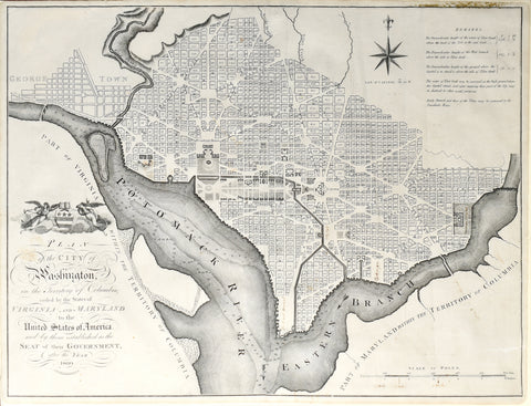
John Russell, Plan of the City of Washington in the Territory of Columbia...
John Russell
Plan of the City of Washington in the Territory of Columbia ceded by the States of Virginia and Maryland to the United States of America and by them established as the Seat of their Government after the year 1800
Published, London, 1795
Engraving
Paper size: 16 ¼ x 21 ¼ in.
Russell's map of Washington is the fourth earliest plan of the City of Washington, preceded only by the 2 official plans, published in 1792 and the first edition of John Reid's map. The first edition of Reid's map appeared in Winterbotham's An Historical Geographical, Commercial and Philosophical View of the United States, published in New York in 1795. Russell copied Reid's map in an edition of 1795 in London, with the engraver's name listed as John Russell. A second edition of Reid's map appeared in John Reid's American Atlas, published in New York in 1796.
The plan shows Georgetown, the street layout for Washington proper, President's House, Capitol, large green, etc. Attractive compass rose and a decorative cartouche. A scarce and desirable early large format map of Washington.
On January 24, 1791, President George Washington announced the permanent location of the national capital, a diamond-shaped ten-mile tract at the confluence of the Potomac and Eastern Branch Rivers. The original survey was performed by Andrew Ellicott and Benjamin Bannaker (a freed slave). In March of 1791, Major Pierre Charles L'Enfant was appointed by Washington to prepare a plan for the new city, with Andrew Ellicott serving as L'Enfant's assistant. L'Enfant turned out to be difficult to work with, and Thomas Jefferson and Washington ultimately suspended L'Enfant's participation in the project in 1792.
Andrew Ellicott took over the project using, L'Enfant's model as his base for completing the plan of the City. Philadelphia engravers James Thackara and John Vallance and Boston's Samuel Blodget Jr., were hired to produce engraved versions of Ellicott's manuscript plan. However, prior to the release of the large official plans, both engravers also engraved and printed a smaller version of the map. An edition of the map was also printed from Hill's map in red on linen, as a keepsake.
As noted above, before the completion of the official editions of the map, smaller magazine versions of both maps, engraved by Hill and Thackara & Vallance, appeared in the The Universal Asylum And Columbian Magazine (Thackara & Vallance, published March 1792) and the Massachusetts Magazine (Hill, published in about April 1792), thereby becoming the first and second printed maps of the City of Washington. The proof states of the larger official maps were not available until June and July of 1792.
We Also Recommend


