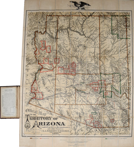

Emil A. Eckhoff and Paul Riecker, Map of the Territory of Arizona
Emil A. Eckhoff and Paul Riecker
Map of the Territory of Arizona
Table of Distances to front pastedown.
Published, New York: The Graphic Company, 1880. First edition.
Fine folding duotone lithographed map with printed color in outline, laid down on cartographic linen in 35 sections
Sheet size: 32 ¼ x 27 ¾ in.
Provenance: With the inkstamp of Frederick Hodges to front pastedown. With inkstamp of "W. B. Walkup & Co., Framers, Map and Chart Mounters, 540 Clay Street, San Francisco."
Large and important map of Arizona as the mineral boom was taking hold, with mining districts designated through outline coloring as well as the counties and Indian reservations, with military telegraphs also shown. There is the Seal of the Territory with signature in plate of J.C. Fremont, Governor. Distances are indicated along the roads. Tombstone, founded a few years earlier, is prominent on the map, with its own district designation, but farther south Bisbee, founded the year the map was published, does not make an appearance. On the inside of the front cover is mounted a leaf of text, titled "Table of distances from and to Different Stations in Arizona Territory to Accompany Official Map."
Paul Riecker, a nationally renowned civil and mining engineer, drew this map from his previous topographical survey of California and Arizona as part of the U.S. Army Corps of Engineers. It is the first official map of the Arizona Territory. Riecker led an early exploration party across the Colorado Plateau and was among the first to make contact with the Havasupai at the Grand Canyon. Paul Riecker sued for homestead rights, thereby creating the origins of Riecker's Addition. He built the first houses north of the railroad tracks in Tucson in 1880. In 1896, Paul Riecker mapped Pasadena, California, and laid out Inglewood and Redondo Beach, California. He was also involved in the Panama-Nicaragua Canal controversy as one of the original surveyors of the Nicaragua Canal route. Phillips Maps, p. 123. Streeter 526. Graff 1204. Rumsey 2980.
We Also Recommend


