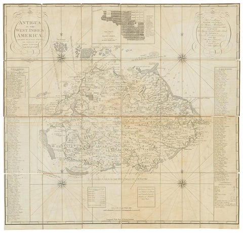
John Luffman (fl. 1776-1820), Antigua in the West Indies America. 1793
John Luffman (fl. 1776-1820)
Antigua in the West Indies America. 1793
Laid down by actual survey ... In the Years 1787 and 1788.
London: William Faden, 1793
Size: 37 x 39 in.
Very rare map of Antigua printed on 4 sheets, surveyed in detail by John Luffman during his 3 year tour in the West Indies. It was published to accompany Luffman's A Brief Account of the Island of Antigua' 1788, but very few seem to have survived. Only 6 copies can be traced in institutional holdings (there are 3 copies [one damaged] in the National Archives at Kew and one each at BL, University of London Senate House Library, and Biblioteca Nacional de España, Madrid). No other example has come up for sale. (ABPC/RBH). Tooley, Printed Maps of Antigua 46.
Folding engraved map on 4 sheets, the whole dissected and mounted onto contemporary linen, relief shown pictorially, coastline marked with obstacles to shipping, shoals, sandbanks, anchorages and soundings, harbours, forts, parishes, churches and mills shown together with the names of property owners, extensive subscribers' list running down both the left- and right-hand sides of the map, inset plan of the town of Saint John at top with a key, dedication to Thomas Shirley, Major General, governor of Leeward Islands, within cartocuhe to upper right, 4 compass roses within sea, scale 1 1?2" to one mile (1:42240), 942 x 983mm (joined).
We Also Recommend