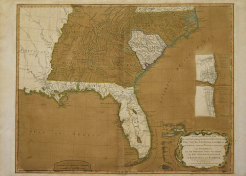
Robert Laurie (C. 1755-1836) & James Whittle (1757-1818) A New and General Map of the Southern Dominion of the United States of America...and the Spanish Possession of Louisiana and Florida.
Robert Laurie (C. 1755-1836) & James Whittle (1757-1818)
A New and General Map of the Southern Dominion of the United States of America...and the Spanish Possession of Louisiana and Florida. [with inset Plans of Charleston & St. Augustine]
From: Thomas Kitchen's A New Universal Atlas
Published: Laurie and Whittle, London, 1794
Engraving with full original hand coloring
Paper size 20 1/4 x 28 1/4"
p.m. 19 3/4 x 25 7/8"
We Also Recommend
![Thomas Jefferys (1719-1771) Carte de la Floride Occidentale et Louisiane. La Peninsule et Golfe de la Florideou Canal de Bahama avec les Isles de Bahama. [Map Showing areas of Florida, Louisiana, The Gulf of Mexico and The Bahamas]](http://aradergalleries.com/cdn/shop/products/jefferys_florida_large.jpg?v=1620314826)