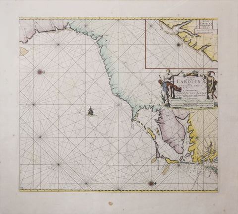
Johannis van Keulen (1654-1715), Pas Kaart van de Kust Van Carolina...
Johannis van Keulen (1654-1715)
Pas Kaart van de Kust Van Carolina...
From: The Geat & Newly Enlarged Sea Atlas or Waterworld
Published, Amsterdam, after 1690
Engraving with original hand-coloring.
Paper size: 24 7/8 x 27 5/8,
Frame size: 32 1/2 x 35”
Johannis van Keulen was the founding member of a family of mapmakers that created a veritable cartographic dynasty in 17th-century Amsterdam, becoming the chief publisher of sea atlases and nautical works during the era. This finely engraved and important chart of the Carolina coast was published in van Keulen's monumental sea atlas, the Zee-Fakkel, considered by many to be the culmination in the development of Dutch pilot books.
The Zee-Fakkel was published in five parts from 1684 to 1689. Part IV of the atlas was the first sea atlas specifically devoted to the New World. It contained some of the most important 17th-century sea charts of American areas, including this one, which has a linear clarity and crystalline simplicity of presentation that are characteristic of the best an most beautiful of Dutch sea charts.
The Zee-Fakkel was the largest and most complete sea atlas to be published to date. As with preceding Dutch atlases of the type, it was designed for the international market, for the publication of hydrographic knowledge throughout the 17th century was predominantly a Dutch affair, under the undisputed leadership of Amsterdam.
We Also Recommend

![Abraham Ortelius (Flemish 1527-1598), Peruviae Auriferae Regionis Typus [with] La Florida Auctore Hieron Chiaves [with] Guastecan Reg.](http://aradergalleries.com/cdn/shop/products/Peruviae_Auriferae-Ortelius_large.jpg?v=1475527180)