Samuel de Champlain (1567-1635) Map of Port St. Louis from "Les Voyages du Sieur de Champlain Xaintongeois, Capitaine ordinaire pour le Roy, en la marine"
Samuel de Champlain (1567-1635)
Map of Port St. Louis from "Les Voyages du Sieur de Champlain Xaintongeois, Capitaine ordinaire pour le Roy, en la marine"
Paris: Jean Berjon, 1613., 1613. Single sheet (image size: 4 2/8 x 5 6/8 inches, 9 x 7 inches sheet).
Exceedingly rare.
Fine engraved map of the Port of St. Louis,otherwise known as Plymouth Colony, Massachusetts, probably by David Pelletier after Champlain, showing the harbour, islands and inlet of Port St. Louis, Native American settlements, French ships, boats and landing parties, with depth soundings numbered in fathoms, a compass rose, and a scale; letterpress key below the image. Provenance: purchased from Richard B. Arkway, New York
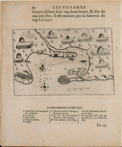
A stunningly early engraved map,AND THE EARLIEST DETAILED MAP of Port St. Louis, or Plymouth Bay,which Champlain visited on July 18th, 1605, from the first edition of Champlain's celebrated account "Les Voyages du Sieur de Champlain Xaintongeois, Capitaine ordinaire pour le Roy, en la marine. Divisez en deux livres. Ou, Journal tres-fidele des observations faites és descouvertures de la Nouvelle France" published in Paris by Jean Berjon in 1613.
This important map of Port St. Louis is complete with a comprehensive key that Patricia Scott Deetz and Christopher Fennell of the Plymouth Colony Archive Project have provided the following interpretation to: A. 'Anchorage,' with his pinnace; B. 'The Channel'(to the inner harbor); C. 'Two Islands' (Clark Island, where members of the third exploration party spent their first night ashore in 1620, and Sasquish Head); D. 'Sand Dunes' (stretching along Duxbury Beach to the Gurnet); E. 'Mud Flats' and a much foreshortened Duxbury Bay; F. 'Cabins where the savages till the soil.', G. 'Spot where our pinnace ran aground' (Brown's Bank, adjacent to Long Beach). H. 'The Gurnet.'
We Also Recommend