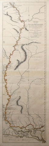
Lieutenant John Ross (d. 1843), Course of the River Mississipi...
Lieutenant John Ross (d. 1843)
Course of the River Mississipi,
from the Balise to Fort Chartres: Taken on an Expedition to the Illinois,
in the latter end of the year 1765.
Engraved map with original hand color in outline.
London: Rob. Sayer, June 1, 1775.
Sheet size: 46 x 21 1/2 in
Ross' map of the Mississippi was the first official English survey of the Lower Mississippi, and one of the most historically significant American maps, delineating the British gains from France in the French and Indian War and later establishing the future western boundary of the new United States. The map opened the area to settlement from the east the beginnings of the Anglo-American mid-South. This handsome map shows on a large scale details, such as islands in the river, navigational instructions, other rivers and connecting tributaries, boundaries, towns and settlements, forts, local history (including the spot where De Soto discovered the Mississippi in 1541), quarries and potential mining areas, productive land, cane fields, and mountains and other topographical details. Tribes located include the Flathead, Choctaw, Chickasaw, Chackhuma, Akansas or the Handsome Men, Wiapes, Corrois, Yazoo, Ofogoulas, Chepoussea, Caskaskias, Colapissas (later known as Huoma), and others.
We Also Recommend