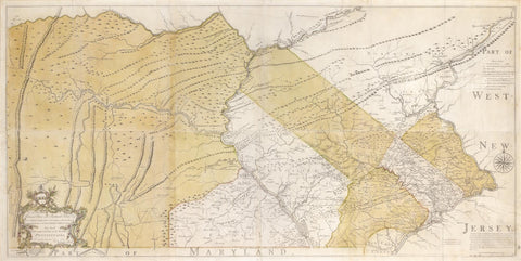
Nicholas Scull (1687-1761), Map of the improved Part of the Province of Pennsylvania
Nicholas Scull (1687-1761)
Map of the improved Part of the Province of Pennsylvania
Philadelphia: Engraved by Jas. Turner and Printed by John Davis for the Author; Published & Sold by the Author, Nicholas Scull, 1 January 1759.
The second state, with the addition of text at Nelson’s Ferry and a road from Carlisle to Pine Ford. Very large copperplate engraved map with hand-coloring on six joined sheets, with a fine cartouche with dedication to the Penn brothers,
formerly folded and now laid to linen, overall 31 1/4 x 61 1/4 in.,
the neatlines about 29 3/4 x 60 in.
Provenance: Collection of John I. Scull, descendant of Nicholas Scull, who gifted the map to Nicholas Biddle Wainwright, also a Scull descendant in 1960; by descent in the family
THE FIRST AND LARGEST MAP OF PENNSYLVANIA TO BE PUBLISHED IN AMERICA
A very handsome example with fine provenance of “the first large scale map of Pennsylvania and one of the most important eighteenth-century maps engraved in what is now the United States” (Streeter). Surveyor and cartographer Nicholas Scull (1700-1762) was the son of a mapmaker of the same name and is known to have been a member of Benjamin Franklin’s Junto. Scull is also believed to have been able to speak the local Delaware Indian language. Scull undertook his ambitious survey at the time of the French & Indian War, when there was little settlement in western Pennsylvania, and the map is a wealth of known information on towns, Native American trails and much else. Wroth noted that this is “The first map of Pennsylvania to be published in America [and] the most ambitious cartographical work to come from an American source before the Revolution.” The map is the largest printed in America in the 18th century.
We Also Recommend


![American School, [Manuscript Map of Pennsylvania]](http://aradergalleries.com/cdn/shop/products/Manuscript_Map_of_Pennsylvania_large.jpg?v=1470162735)