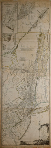
Major Samuel Holland (1728-1801) & Thomas Pownall (1722-1805), The Provinces of New York and New Jersey; with Part of Pensilvania, and the Province of Quebec.
Major Samuel Holland (1728-1801) & Thomas Pownall (1722-1805)
The Provinces of New York and New Jersey; with Part of Pensilvania, and the Province of Quebec.
Engraved map with original hand color.
London: Robert Sayer & John Bennett, 1776
54" x 21 3/4" sheet.
This is Thomas Jefferys' two-sheet map based on the surveys of Major Samuel Holland and Governor Thomas Pownall, published by Sayer & Bennett. Holland originally conducted the surveys to settle a boundary dispute between New York and New Jersey and later as Surveyor for the Northern District for the Board of Trade. These surveys provided the British with essential information for the conduct of the military campaigns in the Revolutionary War.
We Also Recommend


![American School, [Manuscript Map of Pennsylvania]](http://aradergalleries.com/cdn/shop/products/Manuscript_Map_of_Pennsylvania_large.jpg?v=1470162735)