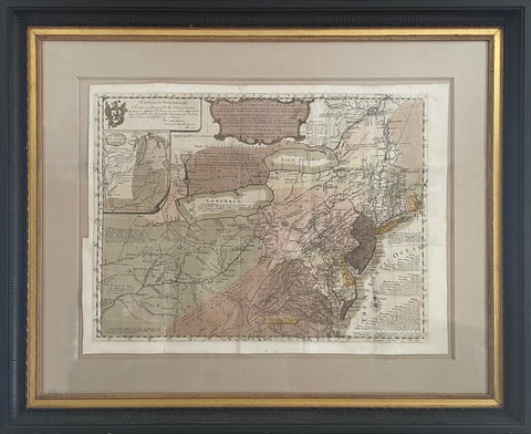
Lewis Evans (1700-1756), A General Map of the Middle British Colonies, in America...
Lewis Evans (1700-1756)
A General Map of the Middle British Colonies, in America; viz Virginia, Mariland, Delaware Pensilvania, New-Jersey New-York, Connecticut, and Rhode Island of Aquanishuonigy, the Country of the Confederate Indians Comprehending Aquanishuonigy Proper, their Place of Residence, Ohio and Tiiuxsoxruntie Their Deer-Hunting Countries, Couxsaxrage and Skanidarade, Their Beaver-Hunting Countries; Of the Lakes Erie, Ontario and Champlain, and Part of New-France Wherein is Also Shewn the Antient and Present Seats of the Indian Nations.
Engraved map with original hand color in full. Philadelphia, 1755 (First State).
Sheet size: 21 x 27 3/4 in.
Frame size: 33 x 40 in.
With Accompanying text volume.
We Also Recommend


![American School, [Manuscript Map of Pennsylvania]](http://aradergalleries.com/cdn/shop/products/Manuscript_Map_of_Pennsylvania_large.jpg?v=1470162735)