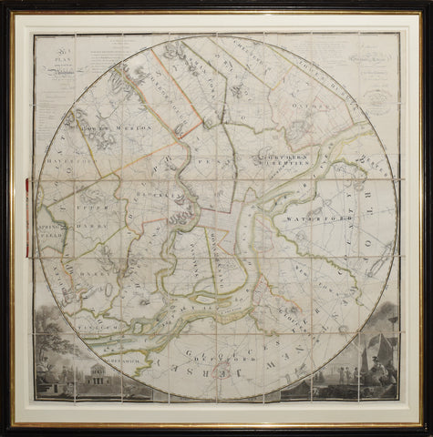

John Hills (fl. 1777-1816), Plan of the City of Philadelphia and Environs
John Hills (fl. 1777-1816)
Plan of the City of Philadelphia and Environs
William Kneass (1780-1840) [Engraver]
Joseph Bradley Varnum (1751-1821) [Publisher]
Engraved map with original hand color, laid down on linen, dissected in 40 sections
Philadelphia, 1808 (1810]
Sheet size: 40 1/2 x 40 5/8 in.
Frame size: 47 1/2 x 47 1/2 in.
A Very Rare, Circular Wall Map of Philadelphia, to a Radius of Ten Miles, showing County Lines, Township Lines, Turnpike Roads, Carriage Roads, Places of Worship, Schools, Gentlemen's Seats, Taverns, Bridges, Mills. There are 10 concentric circles spreading from the center of the city, each one mile in distance apart.
John Hills was a British lieutenant who served as cartographer to Henry Clinton but settled in Philadelphia after the War. He published a highly acclaimed and detailed rectangular map of Philadelphia in 1797, "the work of a master craftsman" (Deak), but this circular version is just as detailed, greatly graphic, and printed in America. The corner vignettes depict the center point of this map: the Water Works in Centre Square as designed by Benjamin Henry Latrobe; and a busy harbor scene with stars and stripes flying.
The publication date is given as May, 1808, but Hills continued to update this map and in this example he cites mercantile data through 1 January 1810.
We Also Recommend


![American School, [Manuscript Map of Pennsylvania]](http://aradergalleries.com/cdn/shop/products/Manuscript_Map_of_Pennsylvania_large.jpg?v=1470162735)