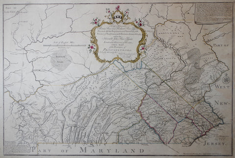

William Scull (1739-1784), To the Honourable Thomas Penn and Richard Penn Esquires..the Province of Pennsylvania...
William Scull (1739-1784)
To the Honourable Thomas Penn and Richard Penn Esquires..the Province of Pennsylvania...
Printed, James Nevil, Philadelphia, 1770
Engraving with original outline coloring
Engraved by Henry Dawkins
p.m. 22 x 32 1/4"
Frame size 29 x 43"
Ref: Wheat & Brun 425
To the Honourable Thomas Penn and Richard Penn Esquires..the Province of Pennsylvania...
Printed, James Nevil, Philadelphia, 1770
Engraving with original outline coloring
Engraved by Henry Dawkins
p.m. 22 x 32 1/4"
Frame size 29 x 43"
Ref: Wheat & Brun 425
The first map of Pennsylvania showing the southern border based
on the Mason Dixon survey
This important 1770 map of Pennsylvania was created by cartographer William Scull for the brothers Penn, Thomas, Richard and John. The map was commissioned by the Penns to ensure that the borders of their province were properly documented, as well as to detail the settled parts of the province itself. Scull was chosen for not only his acumen as a surveyor, but also due to his family connections. In 1759, before William’s appointment, his grandfather Nicholas Scull was commissioned by the Penns to create a map of similar purpose. Using his grandfather’s map, as well as his own successful 1769 surveys of Lancaster, Cumberland, Northampton and Berks Counties, Scull produced the first map of the province of Pennsylvania having its southern line based firmly upon the survey that Charles Mason and Jeremiah Dixon had concluded two years earlier.We Also Recommend


