Pierre Mortier (1661-1711), Carte Particuliere de Virginie, Maryland, Pennsilvanie, La Nouvelle larsey. Orient et Occidentale.
Pierre Mortier (1661-1711)
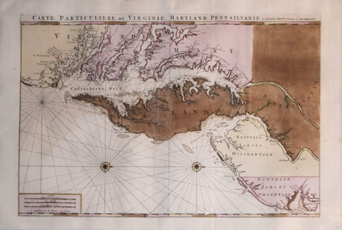
Carte Particuliere de Virginie, Maryland, Pennsilvanie, La Nouvelle larsey. Orient et Occidentale.
Published: Amsterdam and Paris, 1700
Engraving with original hand color
Sheet size: 35 7/8" x 24"
Frame size: 47 1/4" x 35 1/2"
Centered on Maryland and the Chesapeake Bay area, this large-scale map is one of the most beautiful in the history of the cartography of the region. Mortier's spectacular atlas of sea charts, the Neptune Francois, was a production of such beauty and quality that some scholars have assumed it was intended more as a showpiece than as a working atlas for pilots at sea. While this would account for the magnificence of its production, it was in fact a seminal work in the development of sea-atlases. At the time of its production it was the most expensive sea-atlas ever published in Amsterdam, its charts larger and more lavishly decorated than those of any preceding book of this kind. For the engraving and etching Mortier recruited the most qualified artists and sought the most accurate geographical information.
Included in the third part of the Neptune Francois, the Carte Particuliere de Virginie was one of seven charts devoted to America. Much of Mortier's information came from Augustine Herman's map of 1673. The coast is delineated from southern New Jersey to beyond Cape Henry, and marks soundings in fathoms, shoals by shading. A foremost example of the most spectacular type of maritime cartography ever produced in 17th century Amsterdam, Mortier's map shows the Chesapeake on the grandest scale and in great detail.
We Also Recommend


