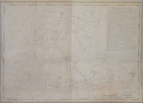
Joseph Frederick Wallet Des Barres (1721-1824), Barrington Bay...
Joseph Frederick Wallet Des Barres (1721-1824)
Barrington Bay...
From: The Atlantic Neptune
Published, London, 1777-1781
Engraving
Paper size 30 x 41 1/2”
Image size 29 x 41”
A magnificent chart from Des Barres's superb atlas, The Atlantic Neptune, published for the use of the Royal Navy of Great Britain... under the Directions of the Right Honble. the Lords Commissioners of the Admiralty. London, [1774-1781], which included a comprehensive survey of the coasts of Nova Scotia, the coasts and harbors of the Gulf and River of St. Lawrence and the Atlantic coast of North America from New York to Mexico, and New England, in more than 100 engraved charts, views and elevations.
Des Barres's service to the British Crown began in about 1752 when he enrolled as a cadet at the Royal Military Academy at Woolwich near London. Founded in 1741 the Academy was established to teach all the branches of mathematics necessary for men who would serve in the Artillery or as Engineers. Des Barres had already received an extensive education in his native Switzerland where he had studied both applied and theoretical mathematics at the University of Basle. Upon the completion of his training he became one of the first officers to be commissioned in the newly formed Royal American Regiment. Thus, it was that at the close of the French and Indian War, Des Barres was sent to America by the British Admiralty to survey the coasts of the Maritime Provinces. These provinces, so recently acquired from France, had never been adequately mapped, and Des Barres spent the next ten years constructing a series of charts of unparalleled accuracy and beauty. Ultimately the project was expanded to include the entire Atlantic and gulf coasts of North America and his findings were published in the monumental "Atlantic Neptune".
Copies of The Atlantic Neptune were compiled as they were ordered, principally for naval captains or merchant mariners, and therefore no standard collation exists and no two recorded copies will contain the same compliment of charts, nor be bound in exactly the same sequence.
"Nautical charting took an unprecedented leap toward greater precision and graphic sophistication with the publication of Des Barres's Atlantic Neptune... The Neptune provided the first generally accurate charts of many areas, and it was relied upon well into the nineteenth century. Des Barres also standardized many of the symbols, such as for navigational hazards, that are found on nautical charts to this day... Not only were Des Barres's charts technically superior to earlier works, but they were also objects of fine printing and possessed an artistry that transcended their utilitarian purpose. Moreover, this was achieved on works that were often breathtakingly large in scale, with some charts measuring over ten feet in length... Most of the surveys on which the charts of the Neptune were based were conducted between 1763 and 1773. Des Barres was then commissioned to assemble these surveys, which included his own fine work in Nova Scotia, prepare their engraving, and have them bound into usable format. Surveys of the New York and New England areas were carried out by various officers under the command of Major Samuel Holland, one of the most capable of all colonial cartographers... In some but not all cases, Des Barres provided the names of the actual surveyors of the charts... When war with the American colonies broke out, the need for good charts of American waters became imperative, and in the years prior to the war, Des Barres project was given high priority. Between 1776 and 1779, Des Barres and his more than twenty assistants had taken over two London townhouses to complete the Neptune" (Paul E. Cohen and Robert T. Augustyn, Manhattan in Maps 1527-1995, New York, 1997, pp.66-69).
We Also Recommend


