John Speed (1552-1629), A New Description of Carolina...
John Speed (1552-1629)
A New Description of Carolina...
From: The Theatre of the Empire of Great Britain
Published, London, Thomas Bassett & Richard Criswell, ca. 1676
Engraving
p.m. 15 x 20"
Frame size 27 1/4 x 31 1/2"
Ref: Cumming, The Southeast in Early Maps, #77
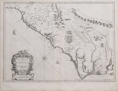
In 1672, a small book was published in London that revolutionized cartography of the American Southeast. This book was The Discoveries of John Lederer, a report of three exploratory expeditions west and southwest of the Virginia settlements, made by a young German scholar and traveler. Included in the account was A Map of the Whole Territory Traversed by John Lederer in His Three Marches. Lederer had appeared on the American colonial scene in 1670, and remained for five years to engage in major exploration of the present-day Carolinas. Abandoned by fellow British travelers who found the difficulties of travel distasteful, in May of 1670 Lederer pushed south below present-day Richmond with one Indian guide, a Susquehanna named Jackzetavon. By mid-June he had reached the site near present-day Hillsborough, North Carolina, and by June 21 he had reached the Uwharrie Mountains, which he mistakenly took for the foothills of the Appalachians. Lederer's journey probably came to an end near the present-day border of North and South Carolina, but he nonetheless described a probably mythical land that lay below, with a great lake thirty miles across, a vast stretch of "savana," and a "great desert" that took him twelve days to cross, the so-called "Arenosa Desert" leading to the Appalachians.
Lederer's errors were probably not fabrications, exactly, but major misconceptions and false assumptions about the geography of the Carolinas. Nonetheless, through publications like The Discoveries of John Lederer, his explorations became widely influential for the cartography of the Carolinas.
This map inspired by the map in the account published just four years before -- was perhaps the most significant agent in diffusing Lederer's "discoveries." The "Arenosa Desert" is duly included, as well as the "Savana" in the Piedmont region and the "Great Lake," perhaps based a glimpse that Lederer had of the Catawba in flood. A full account of Lederer's journeys is given in the text on the map's reverse, leaving no ambiguity as to the source of the information. Compiled by Thomas Bassett and Richard Chiswell, who had acquired the plates for Speed's monumental atlas in around 1674, this map represents a fascinating glimpse into 17th-century perceptions of the Carolina wilderness. Expertly engraved with North oriented to the right, a splendid baroque cartouche, and numerous decorative elements including sailing vessels and a compass rose, this map is a beautiful and extremely significant illustration of history.
We Also Recommend


