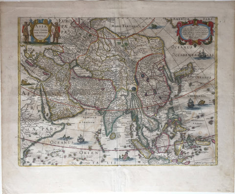
Henricus Hondius (Dutch, 1597-1651), Asia Recens Summa Cura Delineata
Henricus Hondius (Dutch, 1597-1651)
Asia Recens Summa Cura Delineata
Amsterdam: Johannes Janssonius, c. 1640
Copperplate engraving with original hand color
Paper size: 19" x 22 4/5"
Striking Map of Asia from the Dutch Golden Age of Cartography
Fine example of Henricus Hondius’ map of Asia, which appeared in the distinguished Mercator-Hondius atlas.
The map encompasses the entirety of the continent, including the Arabian Peninsula, the Indian subcontinent, Maritime Southeast Asia, and Japan. A sliver of the American continent, separated from Asia by an unnamed strait, is in the upper right corner. In the lower left, a considerable portion of East Africa is featured.
Place names are spread throughout the map, but they are especially thick in the Arabian Peninsula, Persia, and Southern India. There are fewer toponyms and less definite borders in parts of Maritime Southeast Asia, Nova Zembla, and Northeast Asia. These areas were still being encountered and charted by Europeans, hence their lack of assurance here. Korea is shown as a peninsula, which is different than on a comparable contemporary map by Blaeu. Japan is shown in a horizontal position, a typical depiction for the early seventeenth century.
Although focused on the geography of the continent, the map also has a few embellishments. In Africa, there is a pair of lions in Egypt. An elephant is in upper India, near Lake Chiamay, said to be the source of the Ganges. Both a note and a depiction of the Great Wall of China separate China from Tartary. At sea, several ships—European and Chinese—are sailing. They would do well to look out for sea monsters, which are also in the waters. A cherubic mermaid is also in the water, blowing a horn.
The title cartouche is in the upper left corner, tucked into mainland Europe. Two leather-clad hunters, with bows and arrows, flank the strapwork cartouche. In the opposite top corner, another cartouche, strapwork with floral laurels, carries a dedicatory note to Eylhardo Lubino, or Eilhard Lubin. Lubin (1565-1621) was a German humanist and a Lutheran theologian. He worked as a professor at the University of Rostock; he published works on the Classics, as well as a map of Pomerania.
The Dutch Golden Age and cartography
In the late 1500s, seven Dutch provinces in the northern Netherlands achieved independence from Spain and formed the Dutch Republic. Though the Dutch state was small and ruled by a decentralized system of control, it managed to cultivate a powerful seventeenth-century sea empire based on trade. This era became known as the Dutch Golden Age.
Due in large part to their powerful trade empire, the Dutch became known for cartography in the seventeenth century. Their publishing houses produced the highest quality work in Europe, particularly those maps and charts of foreign lands, and Dutch map-making set the bar for cartographic accuracy and artistry into the early-eighteenth century.
The Dutch in the East Indies
Although the map shows all of Asia, of especial importance are the islands of Southeast Asia: Borneo, Sumatra, Java, Celebes, the Moluccas, and others. The Moluccas were the vaunted Spice Islands, originally the only source in the world for nutmeg, mace, and cloves. The Portuguese were the first Europeans to gain power in the region, trading for spices in the Moluccas and controlling the spice market in Europe.
The Dutch wanted in on the lucrative trade, but they also had to contend with the Portuguese. The first Dutch expedition, led by Cornelis de Houtman in 1595, avoided India, the Strait of Malacca, and the Moluccas—Portuguese strongholds—in favor of the Sunda Strait. The Dutch set up their trade centers on the island of Java, at Bantam and, later, Batavia. After Houtman, the second Dutch expedition (1598-1600) quickly set sail for the East Indies. It was followed by five others; the Dutch merchants were eager to exploit the opportunity. In 1602, the most powerful of these merchants and the Dutch government, the States General, created the Dutch East India Company (VOC), a monopoly to control the East Indies trade.
The Mercator-Hondius Atlas and this map
This map was based on an earlier (1623) map by Jodocus Hondius the Younger, with the decorative carte-a-figures panels removed. One of Hondius’ most successful commercial ventures was the reprinting of Mercator’s atlas, where this map appeared from ca. 1630 onward. Gerard Mercator died in 1594 without having completed his most ambitious project, an atlas of the entire world. His son and grandsons completed the work and released its final volume in 1595.
The younger Mercators released another edition in 1602, but they then sold the plates to Jodocus Hondius the Elder in 1604. Hondius published his first edition 1606 and in subsequent editions; there were roughly fifty editions in various European languages in the seventeenth century.
Hondius died in 1612, at only 48 years of age, after which time his son of the same name and his other son, Henricus, took over the business, including the reissuing of the Mercator atlas. After 1633, Hondius the Elder’s son-in-law, Johannes Janssonius, was also listed as a co-publisher for the atlas.
We Also Recommend


