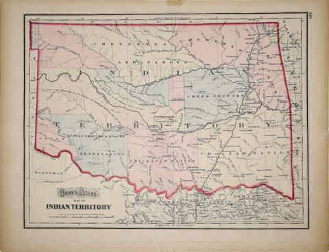
GW & CB Colton, Map of Indian Territory
One of the earliest obtainable separately issued atlas maps of Indian Territory.
The present example bears the imprint of GW & CB Colton, 1872, reflecting the cooperation between the two publishing firms during this period, as both Colton and Gray were issuing maps of Indian Territory in this period. The map is colored by tribes and shows a number of early important place names, railroads, forts, Indian Villages and other points of interest. Several early stage roads are also shown, but not named.
Indian Territory was created by the Indian Intercourse Act of 1834, which created unorganized lands reserved for the relocation of Native Americans. Indian Territory traces its roots to the British Proclamation of 1763, which limited European settlements to the lands east of the Appalachian Mountains. A series of subsequent treaties and government actions under first British and later American rule pushed the Native Americans further west, until the lands allocated by the 1834 Act were set out. Indian Territory became the area to which Native Americans were relocated under the Indian Removal policy which was formalized by Act of Congress in 1830. The primary tribes relocated were the Cherokee, Chickasaw, Choctaw, Creek and Seminole, during an exodus referred to as the Trail of Tears. Late, the Delaware, Cheyenne and Apache were also forced to this region. The tribes set up a number of modern towns, including Tulsa. During the American Civil War, Indian Territory fought on the side of the Confederacy and was the last area to surrender, under the command of General Stand Watie on June 23, 1865.
Over time, Indian Territory was reduced in size to what became the present day Oklahoma, through a series of annexations in the north. In1890, the western part of the Territory became Oklahoma Territory. In 1905, a petition for admission to the Union was made for statehood under the name Sequoyah, but this idea was rejected, in favor of creating the current state of Oklahoma in 1907, at which time Indian Territory ceased to exist.
We Also Recommend


