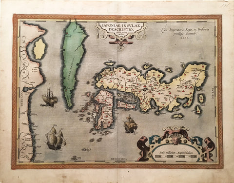
Abraham Ortelius (1527-1598), Iaponiae Insulae Descriptio
Abraham Ortelius (1527-1598)
Iaponiae Insulae Descriptio (Japan)
from Theatrum Orbis Terrarum
Published: Antwerp, 1595
Copper plate engraving with original hand-color
Plate mark: 14 x 19"
Paper size: 16 3/4 x 21 1/4"
A Landmark Map in the Cartography of Japan, from Ortelius’s Groundbreaking “Theatrum Orbis Terrarum”
The first map of Japan to be included in any European atlas, Ortelius’s Iaponiae is rightly celebrated for distinctive beauty as much as for outstanding discovery. Ortelius had received the prototype for Iaponiae along with a map of China in 1592 from Portuguese Jesuit and mathematician Luis Texeira, who was the cartographer to the court of the Spanish king. The foundational map in the cartography of Japan, Ortelius's Iaponiae formed the model for most European maps of the archipelago for the next forty years. This particular example is especially fine, for it is in flawless condition, with vivid original color.
The atlas published in 1570 by Abraham Ortelius was a watershed in the growth and illustration of geographical information. The Theatrum Orbis Terrarum was the first atlas in the modern sense of the word, as Ortelius compiled the best existing maps, re-engraved them on a standardized format, and included them with text in one volume. This was a landmark innovation, and the Theatrum was arguably the first printed production to have a major impact on the world perspective of contemporary Europeans.
We Also Recommend
![Abraham Ortelius (1527-1598), Erythraei sive Rubri Maris Periplus… [Indian Ocean, India, the Middle East and South East Asia]](http://aradergalleries.com/cdn/shop/products/Erythraei_Sive_Rubri_Maris_Periplus_large.jpg?v=1518728684)