John Rocque (1704?-1762) A General Map of North America: In which is Espress’d, The several New Roads, Forts, Engagements &c.. made in the Army employ’d there. From the Years 1754 to 1761.
John Rocque (1704?-1762)
A General Map of North America: In which is Espress’d, The several New Roads, Forts, Engagements &c.. made in the Army employ’d there. From the Years 1754 to 1761.
Drawn by the late John Rocque, Topographer to His Majesty
Published, Mary Ann Rocque, London, ca. 1763
Engraving with original outline hand-coloring
Paper size 33 ½ x 35”
Frame size 44 ¼ x 45 ½”
Ref: Worms, L. & A. Bayton-Williams, British Map Engravers, p.562
Rare French & Indian War Wall Map of North America
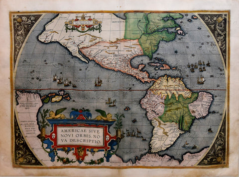
Rocque's map of North America is perhaps the single most accurate map of the whole of the continent to date, including much original western information not found on any other printed map. The map includes the recent Spanish, French and English discoveries in the West and Northwest, with numerous historical and geographical notes including speculation as to the source of the Missouri River.
A large undefined 'West Sea' is placed in the northwest and a note that it is very uncertain whether the region is land or sea. The map is relatively tepid in its depiction of cartographic myths, although speculative notes are shown for several rivers west of the Great Lakes, including Assinipoels R(iver), "which its (sic) thought goes into the west sea."
The map includes a number of early roads, including roads reaching the Taos, New Mexico area, and early road to Texas and throughout the Southern British Colonies.
Fort Orleans (established in 1723) on the Missouri River is shown, one of the earliest European Forts west of the Mississippi River in what would become the future United States.
Wheat notes that the map is an interesting map for the Mississippi Valley and the country to the west, especially good for what is now Arizona, showing all the villages named for the Apostles on Rio des Apostres (the Gila River). Fort St. John is shown in Texas on the Rio Grande, as is the road through Texas to Mexico. Another fascinating note describes Santa Fe and New Mexico.
The boundaries of New England and Virginia by various early 17th Century charters extending to the West Coast are noted, with the boundaries plotted from the Atlantic to the Pacifica.
Only two other known examples the Streeter Sale (1969, Lot 3911).
We Also Recommend
![Abraham Ortelius (Flemish 1527-1598), Peruviae Auriferae Regionis Typus [with] La Florida Auctore Hieron Chiaves [with] Guastecan Reg.](http://aradergalleries.com/cdn/shop/products/Peruviae_Auriferae-Ortelius_large.jpg?v=1475527180)