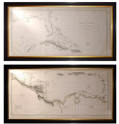


Aaron Arrowsmith (1750-1823). Chart of the West Indies and Spanish Dominions in North America
Aaron Arrowsmith (1750-1823)
Chart of the West Indies and Spanish Dominions in North America
London, 1803
Engraving with original hand-coloring, four sheets joined as two.
52 x 57 1/2 in. (sheet size)
The 1803 first edition of Aaron Arrowsmith’s large-scale map of the West Indies, Mexico, and the surrounding territories offers an extensive depiction of the Caribbean region. Stretching from the Pacific coast of Mexico to the Leeward Islands, the map encompasses the Caribbean Sea and its principal islands, together with the adjacent mainland. It is dedicated to Admiral John Willett Payne, a British naval officer whose connections to the West Indies and prominent position in British society made him a fitting recipient of the dedication. At the time of its publication, the chart was regarded as an important advance in the geographical representation of this part of the Americas.
Arrowsmith compiled the map using a range of geographical sources and surveys available to him. Among these were the earlier surveys of John William Gerard De Brahm along the Georgia coast, the work of Bernard Romans in Florida, and Spanish surveys documenting the Texas coastline and the Gulf of Mexico. Research into the map has also identified the Spanish chart known as the Carta Esférica, published in 1799, as an important source for the Gulf Coast. This chart included the names of Galveston and Bernardo Bays, while Arrowsmith’s version showed an improvement in the positioning of Sabine Pass. Subsequent editions covered a smaller area to the west, ending along Mexico’s eastern coastline, possibly because Arrowsmith later published a separate large-format map of Mexico in 1810.
The map’s dedication honors John Willett Payne (1752–1803), a British naval officer born on the Caribbean island of St. Kitts. Beyond his military career, Payne maintained a close relationship with the Prince of Wales, serving as his private secretary and household comptroller. He also represented Huntingdon in Parliament beginning in 1780. Returning to naval service in 1793, Payne distinguished himself during the Battle of the Glorious First of June in 1794 and received a gold medal in recognition of his service. He attained the rank of rear admiral in 1799 and subsequently became treasurer of Greenwich Hospital. He remained in that position until his death in 1803.
Aaron Arrowsmith (1750–1823) established himself as one of Britain’s leading mapmakers during the late eighteenth and early nineteenth centuries. Although little is known about his formal education, he is believed to have received mathematical instruction from William Emerson, a writer on mathematical subjects. Arrowsmith moved to London around 1770 to pursue employment in the cartographic trade. He is thought to have worked with map publisher William Faden before joining the establishment of John Cary in the early 1780s. One of his earliest documented contributions involved providing measurements for a publication showing the roads between London and Falmouth. In 1790, Arrowsmith established his own business, beginning a highly productive career that spanned approximately three decades. His maps became known for their precision, refined engraving, and careful use of geographical information, qualities that are clearly demonstrated in his 1803 chart of the West Indies and Spanish territories in North America.
We Also Recommend