Girolamo Ruscelli (ca. 1504-1566) Tabula Europae X [Greece]
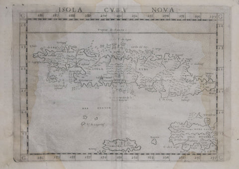
Girolamo Ruscelli (ca. 1504-1566), Isola Cuba Nova
Girolamo Ruscelli (Italian, ca. 1504- 1566) Africa Minor Nuova Tavola [North Africa]
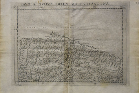
Girolamo Ruscelli (Italian, ca. 1504- 1566) Tavola Nuova Della Marca D’Ancona
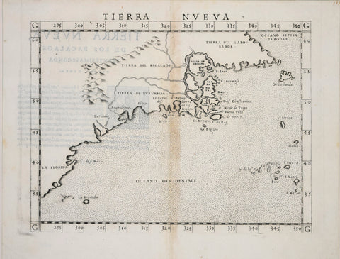
Girolamo Ruscelli (Italian, ca. 1504- 1566), Tierra Nueva
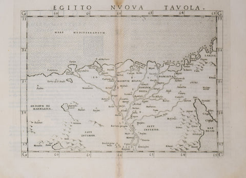
Girolamo Ruscelli (Italian, ca. 1504-1566), Egitto Nuova Tavola
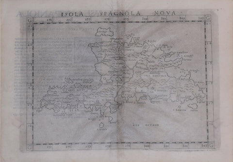
Girolamo Ruscelli, after Giacomo Gastaldi (ca. 1500-1565), Isola Spagnola Nova
Giuseppe di Rossi (1570 – 1639) [After Jodocus Hondius (1563-1612)], Terrestrial Globe
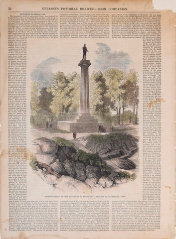
Gleason's Drawing Room Companion, Representation of the Monument to Henry Clay, erected at Pottsville, Penn.
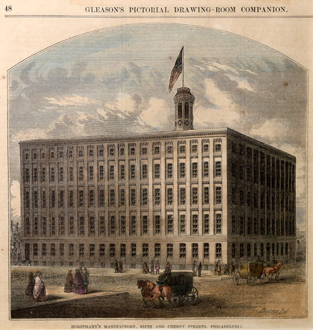
Gleason's Pictorial-Drawing Room, Horstmann's Manufactory, Fifth and Cherry Streets, Philadelphia
Gleason's Pictorial-Drawing Room, [View of Philadelphia]
Gösta Sundman (Finnish, 1854-1914), Arctic Char
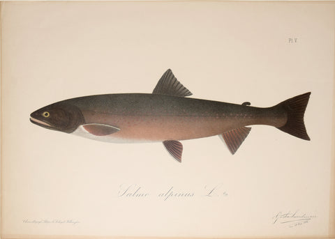
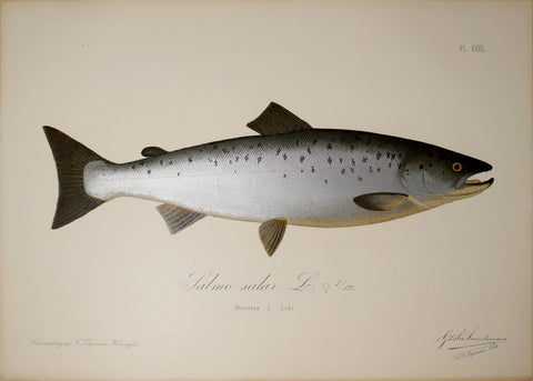
Gösta Sundman (Finnish, 1854-1914), Atlantic Salmon
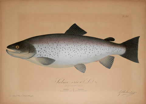
Gösta Sundman (Finnish, 1854-1914), Bull Trout
Government Printing Office & Julius Bien (1826-1909), Pl. C [Central Virginia & Various Battle Sites throughout VA.]
Government Printing Office & Julius Bien (1826-1909), Pl. LXIX [Battlefield of Cedar Creek, VA; & Various Battle Sites throughout VA.]
Government Printing Office & Julius Bien (1826-1909), Pl. LXXXI [Wickham's Attack on Fed. Cav., & Various Battle Sites throughout VA.]
Government Printing Office & Julius Bien (1826-1909), Pl. LXXXV [Battle of Cedar Run, VA; & Various Battle Sites throughout VA.]
Government Printing Office & Julius Bien (1826-1909), Pl. XCIV [A Map of a Line of Defenses in the Alleghanies.. & Various Battle Sites throughout VA.]
Government Printing Office & Julius Bien (1826-1909), Pl. XCIX [Battle Field of Winchester, VA; & Various Battle Sites throughout VA.]
![Girolamo Ruscelli (ca. 1504-1566) Tabula Europae X [Greece]](http://aradergalleries.com/cdn/shop/products/ruscellieuropaexgreece_large.jpg?v=1614288376)
![Girolamo Ruscelli (Italian, ca. 1504- 1566) Africa Minor Nuova Tavola [North Africa]](http://aradergalleries.com/cdn/shop/products/ruscelli_africa_large.jpg?v=1624309411)
![Giuseppe di Rossi (1570 – 1639) [After Jodocus Hondius (1563-1612)], Terrestrial Globe](http://aradergalleries.com/cdn/shop/files/Rossi_TerrestrialGlobe_1615_FullView_large.jpg?v=1683059784)
![Gleason's Pictorial-Drawing Room, [View of Philadelphia]](http://aradergalleries.com/cdn/shop/products/Gleasons_Pictorial_Philadelphia_large.jpg?v=1512753543)
![Government Printing Office & Julius Bien (1826-1909), Pl. C [Central Virginia & Various Battle Sites throughout VA.]](http://aradergalleries.com/cdn/shop/products/Central_Virginia_-_Bien_large.jpg?v=1493664929)
![Government Printing Office & Julius Bien (1826-1909), Pl. LXIX [Battlefield of Cedar Creek, VA; & Various Battle Sites throughout VA.]](http://aradergalleries.com/cdn/shop/products/Cedar_Creek-_Bien_large.jpg?v=1493664232)
![Government Printing Office & Julius Bien (1826-1909), Pl. LXXXI [Wickham's Attack on Fed. Cav., & Various Battle Sites throughout VA.]](http://aradergalleries.com/cdn/shop/products/Plate_LXXXI_large.jpg?v=1489602122)
![Government Printing Office & Julius Bien (1826-1909), Pl. LXXXV [Battle of Cedar Run, VA; & Various Battle Sites throughout VA.]](http://aradergalleries.com/cdn/shop/products/Cedar_Run-_Bien_large.jpg?v=1493664518)
![Government Printing Office & Julius Bien (1826-1909), Pl. XCIV [A Map of a Line of Defenses in the Alleghanies.. & Various Battle Sites throughout VA.]](http://aradergalleries.com/cdn/shop/products/Plate_XCIV_large.jpg?v=1489602407)
![Government Printing Office & Julius Bien (1826-1909), Pl. XCIX [Battle Field of Winchester, VA; & Various Battle Sites throughout VA.]](http://aradergalleries.com/cdn/shop/products/Battlefield_Winchester-_Bien_large.jpg?v=1493663784)