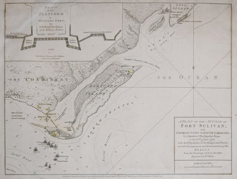
William Faden (1749-1836), A Plan of the Attack of Fort Sullivan near Charles Town in South Carolina...
William Faden (1749-1836)
A Plan of the Attack of Fort Sullivan near Charles Town in South Carolina...
London: Engraved & Published by William Faden, 1776
Engraving
p.m. 11 1/2 x 15 1/4”
Frame size 21 x 24 5/8”
An extremely rare separately-issued Revolutionary War battle plan by William Faden, depicting a critical altercation near Charleston, South Carolina
This highly important and finely engraved map captures the dramatic action surrounding the British naval assault on Fort Sullivan (called here "Sulivan"), the strategic "key" to Charleston, the largest city and only port in the South. It is the third of five states of the map, which was the first Revolutionary battle plan to be drafted by William Faden. In the Spring of 1776, South Carolina had fallen into the firm possession of the Americans, a reality the British were determined to challenge. They dispatched a fleet of twenty ships (although only nine were armed) under Commodore Peter Parker, manned by marines, with the mission under the overall command of Maj. General Sir Henry Clinton. The ships moored in Five Fathom Hole, and landed on Long Island, which lay to the north of Sullivan's Island. The British base, with the original positions of the British ships and with the regiment numbers of marine corps labeled and heightened in red is located towards the upper right of the map.
We Also Recommend


