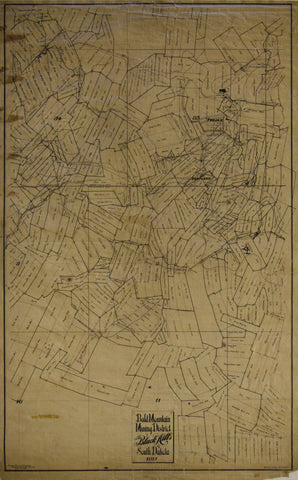
Trojan Mining Company, Bald Mountain Mining District in the Black Hills of South Dakota, 1911
Trojan Mining Company
Bald Mountain Mining District in the Black Hills of South Dakota, 1911
Trojan Mining Company, Deadwood, South Dakota, April 10, 1911
Original manuscript map in black ink on waxed paper
Paper size 47 ¼ x 25 ⅛”
Image size 45 ⅛ x 27 ¾”
The map shows all named mines in the area along with physical features, including creeks and hills, Terry and Foley Peaks, and man-made features such as railroad lines, power lines, pipe lines, buildings, and mills. The area shown is a rich mineral district in present-day Lawrence County, South Dakota, where claims were first staked in 1876, and from which millions of ounces of gold and silver were extracted. Shown on the map is the town of Trojan, presently a ghost town. The principal city in the area is modern-day Lead, site of the famous Homestake Mine, at one time among the largest gold mines in the world, but now closed and filling with water. The Trojan Mining Company operated from 1911 to about 1920 and came into existence the year of this map, when it incorporated several existing mining companies. It was the largest competitor of Homestake Mine in the nearby town of Lead, South Dakota. In February 1922, rising costs forced the mine to close. The company reopened as part of the Bald Mountain Mining Company in 1928 but closed again in 1959.
We Also Recommend