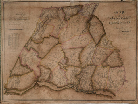
Joshua Scott Map of Lancaster County Pennsylvania.
Joshua Scott
Map of Lancaster County Pennsylvania.
Lancaster, January 1, 1824.
Engraving with original hand-coloring
36 1/2 x 47 1/2"
An early and very rare American county wall map, published in Lancaster in 1824.
This highly detailed county map incorporates nice plans of Lancaster City, the Moravian Society Estate, and other settlements. Hawbaker's index cites 1,335 notations of family names, mills, taverns, and so on. Scott touts the accuracy of his map in a legend at the top left:
This Map Is constructed under a series of Triangles whose Angles have been minutely ascertained to preserve Latitude and Longitude on a Scale of One Inch to a Mile From actual Survey by Courses & Distances of the County, Township, City and Borough boundaries,-The Roads,-The Mill streams, noting all their improvements,-The River Susquehanna on both sides keeping its breadth by intersections,-The Islands, their respective distances from each other and from the shores. The whole carefully protracted.-Also a correct Topographical representation of the Mountains, Ridges and Vallies.
The effort to produce large-scale maps of American counties gained steam in the middle decades of the 19th century, but such maps from the 1820s and '30s are very rare.
John Melish would rely on this and related surveys in the compilation of his famous wall map of Pennsylvania.
We Also Recommend