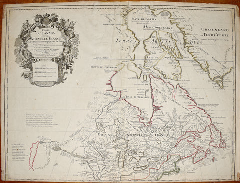
Guillaume de L'Isle (1675-1726), Carte Du Canada ou de la Nouvelle France
Carte Du Canada ou de la Nouvelle France.
Sheet size: 20 x 26 1/4"
Landmark Early Map of Canada & The Great Lakes -- One of The First Maps To Note The Rocky Mountains
A fine example of Guillaume De L'Isle's map of Canada, the Great Lakes and Upper Midwest, one of the most significant maps of region published in the 18th century.
De L'Isle's map is of great importance for the Great Lakes and the Rocky Mountains.
One of the most outstanding maps of Canada of the 17th and early 18th Centuries . . . De L'Isle's careful research resulted in the first map of Canada to present the whole of the Great Lakes correctly. In addition, the position of the lakes relative to Hudson's Bay is also correct, and the Avalon Peninsula is shown much more realistically than on previous maps of Canada. Of considerable significance, the geography of the coastal regions of James and Hudson Bays, together with their major rivers systems, is presented by De L'Isle with a surprising degree of accuracy. (Kershaw)
We Also Recommend
![Abraham Ortelius (Flemish 1527-1598), Peruviae Auriferae Regionis Typus [with] La Florida Auctore Hieron Chiaves [with] Guastecan Reg.](http://aradergalleries.com/cdn/shop/products/Peruviae_Auriferae-Ortelius_large.jpg?v=1475527180)